

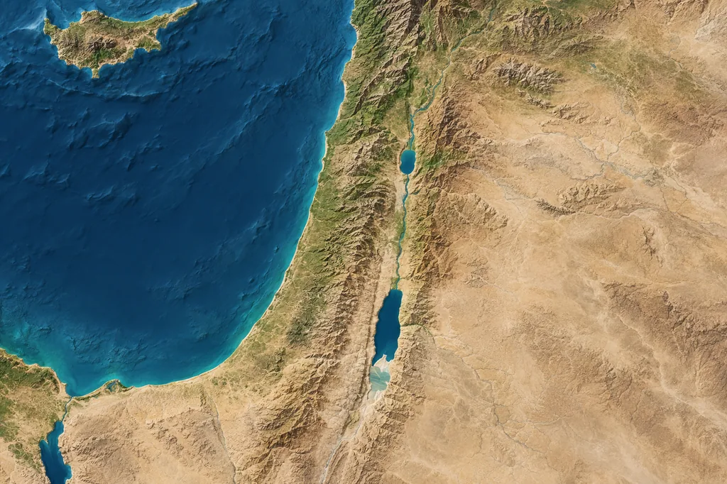
Canaan hugged the eastern Mediterranean, across much of what is now Israel and the Palestinian territories. Its coast, hills, and Jordan Valley form the backdrop to Abraham and Joshua.
Follow its wider reaches north and east, and the map takes in parts of Lebanon, Syria, and Jordan.
On this page
- 011. Start between the Mediterranean and the Jordan
- 022. Four landmarks help you find your bearings
- 033. Egyptian power and local kings shaped the region
- 044. Genesis and Numbers put names on the map
- 055. Canaan and the Promised Land overlap
- 066. The Canaanites lived in a patchwork of cities
- 077. The land stayed while its names changed
| Question | Best short answer |
|---|---|
| Where was its core? | Between the Mediterranean coast and the Jordan Valley |
| What is there today? | Israel and the Palestinian territories, plus parts of neighboring Lebanon, Jordan, and Syria under broader definitions |
| Was it one country? | No. It was a region of cities, kingdoms, and peoples whose borders changed |
| Is it identical to the Promised Land? | Often closely related in the Bible, but not every passage gives the same extent |
1. Start between the Mediterranean and the Jordan
Start on the eastern shore of the Mediterranean Sea. Canaan's core was the land west of the Jordan River, including the coastal plain and inland hill country. On a modern map, that centers on Israel and the Palestinian territories.
Broader ancient and archaeological uses of Canaan reach north into present-day Lebanon and southwestern Syria and sometimes east into western Jordan. The British Museum places the wider ancient Levant across western Syria, Lebanon, Israel, Palestine, and Jordan, while distinguishing the Canaanite culture of the southern Levant.1
That is why maps do not all shade exactly the same area. They may show a biblical boundary from one passage, an Egyptian administrative region from one period, or the wider zone where related Canaanite cultures lived.
2. Four landmarks help you find your bearings
- West: the Mediterranean Sea, called the Great Sea in many Bible translations.
- East: usually the Jordan River and Jordan Valley for the narrower biblical land, though related peoples and territories also lay east of it.
- North: the Lebanese coast and, in broader ancient usage, territory toward Byblos and southwestern Syria.
- South: the Negev and the approaches to Sinai and Egypt, with details varying by text and era.
Canaan sat between Egypt and the great powers of Syria and Mesopotamia. Its ports and inland routes made it a corridor for trade, armies, languages, and artistic influence. The region's geography helps explain why Egyptian, Mesopotamian, and local records all refer to it.
3. Egyptian power and local kings shaped the region
Canaan was a region of cities and kingdoms whose rulers answered to different powers over time. Egypt dominated much of the area during parts of the Late Bronze Age, while local rulers governed their own cities.
The Metropolitan Museum of Art describes Canaanite city-states in the second millennium BC and Egyptian dominance in southern Canaan during the Late Bronze Age. The Amarna archive records correspondence between Egypt and rulers of cities across Syria and the Levant.2
Ancient evidence also shows the name extending northward in some contexts. A sixteenth-century BC inscription on the statue of King Idrimi says he fled to the land of Canaan, probably in southern Lebanon.3 The term's range depended on who was using it and when.
4. Genesis and Numbers put names on the map
Genesis introduces Canaan as both a person in its genealogies and the name of a land. Genesis 10:19 sketches Canaanite territory from Sidon in the north toward Gaza in the south, then inland toward cities near the Dead Sea. Genesis 12 says Abram entered Canaan and traveled through Shechem toward Bethel before going south.
Numbers 34:1-12 gives the Bible's most detailed border description for the land Israel was to receive. Its western edge is the Mediterranean, its eastern line runs through the Sea of Galilee area and down the Jordan to the Dead Sea, and its northern and southern borders are described through ancient landmarks.4
Some of those ancient landmarks remain hard to locate. That gives Bible atlases a puzzle: they must connect the names in a passage with rivers, mountains, and settlements on the ground.
Genesis and Numbers are among the first five books of the Old Testament. Joshua picks up the story as the Israelites cross the Jordan into the land.
5. Canaan and the Promised Land overlap
They overlap, but the names belong to different contexts. Canaan is the older regional name used before and during the stories of Israel's settlement. The Promised Land is a theological phrase for the land God promises to Abraham and his descendants. Israel can mean the people, the later kingdom, or the land associated with them.
In Genesis 17:8, God calls the promised territory 'the whole land of Canaan.' In that passage the terms closely overlap. Elsewhere, biblical land descriptions can be narrower or broader, and the political kingdoms of Israel and Judah did not maintain every boundary named in every promise.
The modern state of Israel covers part of this ancient region. Lebanon, the Palestinian territories, and adjoining lands also preserve places that appear in Canaan's long history.
6. The Canaanites lived in a patchwork of cities
'Canaanites' can refer broadly to people living in Canaan or more narrowly to particular groups named in ancient and biblical texts. They did not form one continuous centralized empire. The region contained independent cities and small kingdoms linked by related languages, trade, religion, and material culture.
Archaeologists describe substantial continuity between Canaanite culture and later peoples of the Levant, including Israelites and Phoenicians. Languages, crafts, and local traditions carried on even as kingdoms and identities changed.1
The Bible also uses group names at different levels. At times 'Canaanites' functions as a broad label for inhabitants of the land; elsewhere it appears alongside Amorites, Hittites, Hivites, Jebusites, and other named peoples.
7. The land stayed while its names changed
The region did not vanish, but its political and geographic names changed. During the Iron Age, Israel, Judah, Phoenician cities, Philistia, and neighboring kingdoms became more prominent labels. Later empires and administrations used names such as Judea, Syria, and Palestine for parts of the same wider region.
Modern historians often use Levant or southern Levant as geographic terms because they do not assume one biblical or political boundary. 'Canaan' remains useful when discussing particular Bronze Age cultures, ancient records, and biblical texts.
Canaan survives as a name in Bible reading, museum galleries, and archaeology. On a modern political map, look for the countries and territories along the eastern Mediterranean instead.
Frequently asked questions
What country is Canaan today?
Canaan is not one modern country. Its core corresponds mainly to present-day Israel and the Palestinian territories, while broader definitions include parts of Lebanon, western Jordan, and southwestern Syria.
Was Canaan in Africa or Asia?
Canaan was in western Asia, on the eastern Mediterranean. It bordered Egypt and the Sinai approaches, which connected it closely with northeastern Africa.
Is Canaan the same as the Promised Land?
The terms closely overlap in many biblical passages. Genesis 17:8 calls the promised territory the land of Canaan, but different passages describe the promised land at different scales.
Is Canaan the same as Israel?
Not exactly. Canaan is an older regional name; Israel can refer to a people, an ancient kingdom, a biblical land, or the modern state. The territories overlap, but the names are not interchangeable in every period.
Where was Canaan in relation to Egypt?
Canaan lay northeast of Egypt along the eastern Mediterranean. Routes across northern Sinai connected Egypt to Gaza and the coastal and inland cities of Canaan.
Does Canaan still exist?
The land still exists, but Canaan no longer exists as a country or administrative region. Historians use the name for an ancient region and its cultures.
References
- The British Museum describes the ancient Levant as western Syria, Lebanon, Israel, Palestine, and Jordan and notes Canaanite cultural continuity in the southern Levant. See British Museum, 'Ancient Levant'. ↩
- For Canaanite city-states, Egyptian rule, trade, and the Amarna correspondence, see Metropolitan Museum of Art, 'The Eastern Mediterranean and Syria, 2000-1000 B.C.'. ↩
- The inscription on the sixteenth-century BC statue of Idrimi places his refuge in the land of Canaan, probably southern Lebanon. See British Museum, 'Idrimi, the 3,500-year-old refugee'. ↩
- See the detailed biblical border description in Numbers 34:1-12. ↩